Followers

Monday, 7 May 2012

Monday May 7th, Parbold - Burscough Junction

Bank Holiday Monday today and quite a few boats on the move, no doubt heading back to their marina or mooring, having been out for the weekend.
We decided to move on as, despite the weather forecast, it had dawned sunny, if a bit breezy. Needless to say, having had a lie in, we moved off just as the sun disappeared and the clouds started to build up.

Once past the moorings at Parbold, the canal crosses the River Douglas on an aqueduct. The river, our companion since Wigan, now heads across country towards Tarleton where it becomes tidal and part of the Ribble Link passage.
Soon after leaving Parbold, we passed our companions of yesterday who had gone on to tie up yesterday in slightly more remote surroundings.

The countryside immediately flattens out as the hills are left behind us. It is an area of intensive cultivation – the first example of which is a large acreage of turf growing. As we passed, they were actually cutting turves from the fully grown grassed area.
The canal squeezes between two sewage farms and a faint whiff of Eau de Sewage assails the nostrils.

The first of the day’s swing bridges arrives near Hoscar. While the barriers have to be swung by hand, everything else is electrically operated.
A pleasant length follows with fields of leeks still being harvested, and a tree nursery. Moored boats line the canal from the Ring O’ Bells pub to beyond Burscough Junction, another swing bridge interrupting progress. This is a full blown traffic light & automatic barrier job, but we were fortunate enough to time it to follow another boat through.
Approaching Burscough Junction

Burscough Junction is a lovely little place, full of canal historical interest. It is here the Rufford Branch bears off under a delightful stone bridge to drop down the 8 locks to Tarleton where it joins the by-now tidal River Douglas. Since the opening of the Ribble Link and the opening of a couple of new marinas, this area is now a lot busier.
Top Lock, Burscough Junction
A swing bridge is situated immediately above the top lock, with the second immediately below. A now private whitewashed residence stands above the top lock. This was the former pub, known by working boatmen as the "Bloodbucket" - as it doubled as a slaughterhouse. Opposite, an old open air dry-dock has stone sets on which boats rested. Beyond is a charming row of old canal cottages dating back to the opening of the branch. Rightly so, the whole area is now a conservation area.
Drydock and cottages, Burscough Junction
By now, the wind had increased in strength and it had started to spit with rain. Not far past the junction we decided to call it a day (just 3 miles!) and tie up. Soon afterwards the rain started in earnest.

Sunday, 6 May 2012

Sunday May 6th, Wigan - Parbold

We enjoyed two nice, quiet nights in Wigan, moving across to the sanitary station on Saturday morning to empty the loos and fill up with water, and then down Henhurst Lock to tie up on the secure moorings outside the BW Regional Office.

To our surprise and delight we tied up behind the boat with which we had cruised with from Aintree to Litherland two years ago – ‘RJ’. They are also doing the link again; they’ve done it every year since it opened! They’re booked for the passage into the docks a bit after us, though.
Wigan Bottom Lock & Drydock
We got to Wigan too late on Friday for the Regional Office’s even more restricted opening hours to get an electricity card for Liverpool, but the TIC in Albert Dock sells them now, so if we’re desperate, we can get one there. What was even more annoying was the notice displayed in their window giving the working hours of the Plank Lane Lift Bridge keeper! He doesn’t work there anymore! ARGGGGHHHH.

Old warehouses at Wigan
This morning, after utilising the BW office rubbish skips, we set off with ‘RJ’ into the bottom lock and were soon on our way through Wigan’s nether regions. Having said that, there is still plenty of interest. A sharp turn to the left brought us to the surviving old warehouses, one now used as a pub whilst the others, at one time housing exhibitions, are sadly now boarded up and empty. Another warehouse with a lovely canal loading arm going under the building lies to the right of the sharp turn and is another pub.
The ubiquitous Wigan Pier follows. It is nothing more than a pair of upturned rails at the site of an old coal tippler. Thanks to George Formby and George Orwell, it has become world famous. Two years ago when we travelled through Wigan, the area below Ell Meadow Lock (on the town’s outskirts) seemed to be the last resting place of every empty plastic bottle in the universe. They have now moved to the area around Seven Stars Bridge. I don’t think I’ve ever seen so many short of a landfill site.

Under a railway bridge and an area of old coal workings is slowly being reused. The impressive DW Stadium, home to Wigan Athletic FC (fighting their annual battle against relegation) and Wigan Warriors – the rugby league club. Other large warehouse type developments continue for some distance, but an older form of employment flanks Pagefield Lock – Pagefield Ironworks, much reduced in size from its Victorian heyday.
Ell Meadow Lock follows, now much cleaner (much less dog crap) and tidier (the plastic bottles have moved). The last few houses and retail units of Wigan’s suburbs usher in countryside at the site of a former lock, lost through subsidence.

By the time you arrive at the twin basins, once colliery basins now used as attractive private moorings, you are at Crooke – a popular mooring site with a busy pub. We utilised the services of Derek on his wide boat ‘Ambush’ when we were here two years ago – he has now returned to his more familiar mooring below Wigan Bottom Lock.
The Douglas Valley
The River Douglas, which we had crossed over on a hard to spot aqueduct immediately after Wigan Junction, comes alongside now and is the canal’s close companion as far as Parbold, 7 miles away. Once navigable itself (although hard to imagine now), it has created an idyllic path along its valley, one that the canal is happy to keep company. Thick woodland flanks both sides, with Ransomes (wild garlic) and bluebells creating a carpet of colour.

Low ridges follow the canal with the trees thinning every now and again to give views of copses and green fields. Busy at work, chewing the grass, cows abound belying the fact that Wigan is just a couple of miles away. The Wigan to Southport railway line follows the canal, but it doesn’t intrude with an infrequent service.
Civilisation briefly interrupts this rural interlude with the railway crossing over just after Gathurst, and the M6 soaring high overhead to clear the river, railway and canal on a series of massive, long legs.

Gathurst was once notable for an explosives factory (now closed) and is now notable for manufacturing Heinz baked beans. From one type of explosion to another perhaps?
Immediately after the M6 viaduct comes Dean Lock. It was once a pair of locks, but one chamber has long been in disuse.

Another long rural length follows interrupted only by the first swing bridge of the day and the village of Appley where we enter Lancashire, a fact proudly proclaimed by the notices. It seems strange that we should be entering this proud county (which we will be in for the next dozen miles or so), as once, we would have been in Lancashire as far back as Dunham Massey, and would remain in it all the way to Liverpool.
But since the appalling insensitive local government reorganisations of 1974 and later, we have been passing through Greater Manchester, Wigan Metropolitan Council and we will subsequently enter Merseyside.

Appley Lock was again once paired, but this time the single deep chamber was paired with two shallower locks alongside. Sadly only the 12’ deep lock is in use today, and can be a right so & so if you’re not careful when climbing up on your own. For us this is the last lock until we start the descent into the docks in Liverpool.
We met a single boat here starting the climb up from the surrounding low lying area. They had only just picked the boat up and the lady (who was working the lock) wanted a bit of reassurance on what to do and what to watch out for.

Canal "junction" at Parbold
Once down the lock, the canal again follows the river through some charming scenery for a couple of miles before reaching Parbold. There is a sort of T-junction here with the route to Liverpool turning sharp left. There is a short stub of water heading away to the right, now used as moorings and before that as a drydock.
This is what is left of the original line of the canal as first sanctioned by Parliament. The line was to pass to more to the north than the present line, and bypass Wigan, Chorley and Blackburn altogether. That, understandably, upset the colliery owners of Wigan and the cotton merchants of Chorley & Blackburn, and in due course, saner counsels prevailed and the present line was built. But not before a short section had been dug out at Parbold.
Mooring at Parbold

Having passed under the road bridge by the attractive former windmill, we tied up for the day. We might stay here two days given the weather forecast for tomorrow and the time in hand we have before our passage into the docks on Friday.

Friday, 4 May 2012

Friday May 4th, Astley Green - Wigan

We wanted to have another early start so as to get to Wigan in good time to get a mooring at our preferred spot just above Henhurst Lock. We actually made it our earliest start of the cruise so far!

The landscape today was almost exclusively more of what we ended up with yesterday, nature’s attempts to reclothe the old coal mining scars with greenery.
A string of old mining villages follow the line of the canal from a distance – Astley Green, Marsland Green, Bedford, Firs Lane, Plank Lane, Crankwood, Abram and Bamfurlong, with the combined coal and mill town of Leigh in between.

Old mills at Leigh
Indeed, once through Astley Bridge, the cupolas and towers of Leigh’s old mills could be seen on the horizon. Past Marsland Green, a steady stream of kids made their way along the towpath to a large comprehensive school on the outskirts of Leigh – some already smoking, and some of the girls looking as if they’d rather be dolled up and enjoying the night spots that Leigh has to offer.
A new Tesco has been developed along with some other identikit retail units along the off side of the canal. Sadly they have not bothered to put in moorings for boaters wishing to avail themselves of the facilities.

Leigh Bridge
Leigh Bridge is the demarcation point between the Leigh Branch of the Bridgewater Canal and the Leigh Branch of the Leeds & Liverpool Canal and we were once again back on British Waterways waters.
After a busy road bridge the canal enters a landscape visibly scarred by coal mining. The land, particularly to the south, has subsided significantly and the canal has had to be built up several times to retain the level. A huge flash has been converted into the centrepiece of Pennington Flash Country Park, which, in addition to having a golf course, has fishing and watersport facilities. It is a very attractive setting and is enjoyed by many walkers, mostly dog owners.

Plank Lane Swing Bridge (actually a lift bridge)
The electrically operated Plank Lane Swing Bridge (actually a lift bridge) caused us a 45 minute delay. It has always been operated by a British Waterways bridge-keeper who is on duty from 8.00 in the morning. It has recently been changed to a boater operated bridge (BW key required) but the power is actually turned off from 8.00 to 9.30 in the morning and from 4.30 to 6.00 in the evening due to “rush hour”. Anyone would think we’re talking about the M25 here, but in fact it is a little by-road to nowhere in particular.
We arrived at 8.40 and had to twiddle our thumbs before the power returned. There has been no notices about the change in use, and even British Waterways’ own ‘Waterscape’ website still gives the bridge-keepers hours on the boaters’ guide to the canal.  ARGGGHHH!

Old pub at Plank Lane - now long gone
When we passed here two years ago, we noticed that the old derelict pub and housing we had seen two years earlier had gone. They had suffered major subsidence and were leaning at every angle .Major land clearance and levelling was under way. This time we found a large open pool of water surrounded by decorative railings had appeared just before the bridge, and that the land behind was all ready for some form of development.
It appears that British Waterways had the idea of creating a marina here with associated leisure use buildings alongside – pub, retail units etc., but has found no takers. It makes a great winding hole though!

Under way again, we continued through the scarred landscape, on one side travelling at tree-top level, so much is the subsidence.
Site of Dover Locks
At the Dover Locks Inn, we passed through the narrows caused by two former locks that have been removed to Poolstock (a bit further on) due to subsidence. An old lock at Plank Lane was also been removed for the same reason.

After a flurry of civilisation at Bamfurlong, where the A58 Liverpool to Leeds road and the West Coast railway line both cross, the canal enters a length of old mine workings reclaimed by gorse, scrub and water to form a network of nature reserves. A few rusting reminders remain of former coal loading shuts where coal was loaded onto wide boats to feed the ever-hungry Wigan Power Station, the site of which is now the Giro headquarters.
Poolstock Bottom Lock
After passing another flash dotted with the coloured sails of dinghies, we arrived at the two Poolstock Locks which raised us about 14 feet and into the suburbs of Wigan. The bottom lock has some unconventional windlasses to open one of the bottom gates.

By now the wind, which had been fairly light, increased in strength and it turned quite cold and it started to spit with rain so we were quite happy to reach the junction with the main line of the Leeds & Liverpool and turn sharp left where we tied up just above Henhurst Lock.
Tomorrow we shall head across to the sanitary station to do the usual jobs, and then drop down the lock to the secure offside moorings outside BW’s Regional Headquarters where we shall stay, probably until Monday when we will start to make our way down to Liverpool.

Wed May 3rd, Dunham Massey - Astley Green

After a lovely quiet night, we were away early this morning. We wanted to get through the urban grot of Salford and western Manchester before lunch, so it was an earlier alarm call to get us under way a bit earlier than usual.

It was another bright, sunny morning, although there was a cool breeze blowing, particularly on the embankment where we were exposed. The couple of miles to the start of the built up area is lovely. Despite the proximity of Altrincham & Sale, it is seemingly remote and pastoral. However, as you pass under Seamon’s Moss Bridge, you know it will be a few hours before you see green fields again.
Oldfield Brow marks the western extremity of the built up area, and ushers in a mixture of modern housing (some with their own mooring basin) and light industry. The canal strides through in long straight stretches, but this initial section is not without interest.
The new flats

The Linotype Works of 1897 are a remarkable survival even if the 20th century has made some totally insensitive alterations to its looks. Towering above everything just ahead are two totally out of place skyscraper blocks of apartments. They rise over the canal in a series of metal steps looking something the prow of the Titanic.

Across the canal they overlook nothing more than a large factory with smoking chimneys, steam gushing pipes and throbbing machinery. Nice. The architect (assuming someone was brave enough to put their name to the plans) must have been “under the influence” when he (or she) came up with these aberrations. It is totally out of place and proportion.
Old canal warehouse
The wonderful adjacent canal warehouse with its arched loading bay lies totally derelict and forgotten right next to the monstrosities, crying out for some sympathetic redevelopment.

A railway bridge brings the first of the morning’s lines of moored boats – an outpost of Sale Cruising Club this time. Under Timperley Bridge the railway comes alongside in the guise of Manchester’s Metrolink. It also announces the start of possibly the most boring stretch of canal in the country (and yes I include Milton Keynes in that assessment…..just) – the Sale Straight.

Apart from a slight “curve”, four miles of mind numbing inactivity awaits. The railway follows the canal so closely on one side that there is just room for a thin strip of rail-side waste land. The other is a mixture of nondescript pre-war housing and light industry. Walton Park introduces a small section of municipally organised greenery whilst rowers were getting ready for the first training runs of the day. We have often had to dodge the rowing boats along here. A more sombre note follows with a huge cemetery that spans both sides of Marsland Bridge.

Marsland Bridge also introduces three-quarters of a mile of linear moorings – the home of Sale Cruising Club. Things can’t get any worse.

Sale Bridge brings a welcome respite to the moored boats; the town centre is just a stones-throw away. Two pubs compete for your custom; the canalside The King’s Ransom has an attractive outdoor seating area and a length of good moorings if you feel so inclined. Personally, I just want to plough on and end the nightmare.

That slight curve I mentioned earlier is next and it is a real thrill to be able to twitch the tiller a little! The next bridge introduces a green section as the canal crosses the River Mersey. It is only a tiddler here compared to what it becomes in a few miles after its confluence with the River Irwell. Mind you, after all the rain we’ve had, it was flowing pretty quickly.

The M60 motorway crosses overhead and its noise follows you for some distance as another line of moored boats await you. These are the moorings of the Watch House Cruising Club. Their headquarters are in an old lengthman’s cottage.

Urban surroundings take over again as we enter Stretford. The gaggle of derelict cruisers at the old Rathbone’s Boatyard (long closed) gets more depressing each time we come by, three have sunk and two are on the verge of doing so. Some residential narrowboats follow.

The surroundings now are a curious mixture of pre-war and very recent housing, with another modern development having its own mooring basin and a new boatyard. The other side of the canal is industrial – the first signs of the huge Trafford Park Industrial Estate.
Waters Meeting

A flurry of railway bridges announces that we are approaching Waters Meeting, the junction of the original Bridgewater line from Worsley to Manchester and the later line to Runcorn, although the Manchester – Runcorn line is now considered to be the ‘main ‘ line.

The name Waters Meeting conjures up an idyllic sylvan glade with two limpid streams gently merging. Instead, you are faced with a pipe bridge and a container terminal as your surroundings. All very prosaic.

More long straights lie ahead as the canal passes through the Industrial Estate. Kellogg’s’ factory is first up with the loading arm still in water although it is gated and boomed off. The rest of the passage through the industrial grot is of no interest. The industry does not recognise the canal being separated by coils of barbed wire. Fortunately trees line both banks hiding the worst excesses.

A short length of mooring rings are provided if any boaters feel they want to let their other halves run amok with their flexible friends in the huge Trafford Park Shopping Centre. All the same chain store names that you would find in any major High Street or other major out of town shopping centre are present in a complex of buildings that must have been designed by the same architect as the flats we passed earlier. An appalling combination of Italian campanile, Hindu temple dome and Moorish balustrades “adorn” this pastiche of all that is wrong with late C20th bling.
Entering 'The Tank'

Fortunately, it is soon out of sight as the canal curves round to one of the Seven Wonders of the Waterways – the Barton Swing Aqueduct. Entering a steel trough, you pass high above the Manchester Ship Canal. The aqueduct replaced Brindley’s original stone built structure across the Irwell Navigation when the Ship Canal was built to allow sufficient headroom for ships to pass up the Canal to Manchester Docks, the whole steel structure swinging open on a central pivot. Sadly it is little used these days. This is our fifth journey through “The Tank”, and we have never seen it swing.
Manchester Ship Canal from 'The Tank'

However, during our stay in Liverpool we are taking a boat trip from Birkenhead, up the Mersey to Eastham Locks, into and along the Ship Canal to Salford Quays, so will be able to cruise under it even if it doesn’t need to swing for us.

The canal now enters an intensely urban section as it passes through Salford’s outer suburbs of Barton, Patricroft, Eccles, Monton and Worsley. A road comes alongside the towpath with terraced housing facing across the canal, which is fringed by trees, weeping willows and flowering cherries among them. It is all rather charming and  almost Fenlike in its character.

Having said that, there is the downside of another line of moored boats – this time from the Worsley Cruising Club. Fortunately they don’t last too long. The canal starts to wind in a most unfamiliar fashion as it passes under a railway line and past the demolished remains of an old mill that used to glory in the name “Eccles Spinning and Manufacturing Company”.

The waterway starts to turn the colour of tomato soup again, as at Harecastle Tunnel. The reason is the same - iron oxide leaching out from underground workings - this time at Worsley Delph a couple of miles away.

The Monton Lighthouse

Another motorway crossing, this time the M602, brought us to one of those amusing little quirky sights the canals have a habit of throwing up at us – The Monton Lighthouse. Yes, a lighthouse. It seems that a chap living in an upmarket parkhome/chalet was upset when his view across Monton Pool was partially blocked by a new block of flats. So rather than being beaten, he got even and built a lighthouse in his garden – complete with observation tower and electric light at the top. Good for him!

Woods appear on the off side as the canal strides across an embankment to approach Worsley. New housing of a very upmarket style has crept east from Worsley, but there is a clear demarcation between the Monton & Worsley.

The Packet House, Worsley
Worsley Delph - twin entrances to the old coal mines
I always get a bit of a buzz when we approach Worsley. This was where the Canal Age really started with the Duke’s canal from his mines here to Manchester. The whole area is redolent with history, and although this time we cruised straight through, we have stopped here before and taken in the sights. Be it the Packet Boat House, Lord Ellesmere’s boathouse, Worsley Delph with its twin mouseholes – the former entrances to the mines or the twin covered drydocks (surely contenders for the oldest drydocks on the canal network), there is something somewhere to catch your interest. The former Leeds & Liverpool fly-boat ‘Dee’ was visible in the docks.


Worsley Dry-Docks


The former L&L flyboat 'Dee'
As yesterday at Moore, Elaine alighted to walk across the park and across the road to the shop for a paper before getting back on again before the sharp turn left under Worsley Bridge. Immediately after comes the third motorway crossing of the day with the M60 soaring overhead again.

Once past the flurry of sliproads, the canal sets out for Leigh and Wigan, more often than not on heightened banks as land around it has subsided. Woods mark the approach to Boothstown basin, now the site of Bridgewater Marina. In 2008 we had to fill up with diesel here and paid 90p a litre for the privilege – even after all the recent price increases, we still pay less than that now from our fuel boat. We would never use them again!

Journey’s end was now in sight as we cruised through a landscape still struggling to cope with the aftermath of the cessation of coal mining. Small brick built buildings hint at pumping activity still going on while concrete or brick foundations are all that remain of buildings long forgotten. Nature is slowly reclaiming the land with gorse and silver birch colonising the sides of the tracks that line both sides of the canal.

Astley Green Colliery - former headstock
The headstock and winding gear of Astley Green Colliery stand up stark on the horizon as we near our mooring place. The busy by-road that crosses the canal at Astley Green marks good moorings with two pubs, a fish & chip shop and the Astley Green Mining Museum. This is run by local enthusiasts and appears to receive little help from the major grant giving bodies and is all the better for it. A devoted band of volunteers have developed a gem of a museum within the old colliery and give a vivid insight into virtually the only way of life the local men ever knew. If you happen to be there on Sunday, Tuesday or Thursday afternoons, take a couple of hours out to visit it.

Wednesday, 2 May 2012

Wednesday May 2nd, Daresbury - Dunham Massey

Just can’t seem to get two day’s weather the same. Fortunately it was the right way round this time with blue skies and sunshine for most of the day; a welcome change after all the rain, which bucketed down again yesterday late afternoonish.
Daresbury Lab Tower
Once under way we were treated to a fine view of Fiddler’s Ferry Power Station with a lot of steam pouring vertically from its cooling towers before all turning north-west in unison.
The Daresbury Atomic Research Laboratory with its iconic tower has a long and attractive canal frontage with neatly manicured lawns and seating areas for its boffins. “No Mooring” signs proliferate, but then they go and spoil it with a line of concrete wharf wall lined with large mooring rings. Did they once get coal deliveries by boat?

Passing under the Runcorn Expressway link to the A56 the canal reverts to open countryside for a few miles passing the little village of Moore, where we once moored (pardon the pun). I dropped Elaine off here so she could nip to the village shop for a newspaper.
The A56 crosses the canal at the western extremity of Warrington’s suburbs on an unusually designed bridge for a road - I think it is a bow string girder bridge. Here we came across what for me is the bane of the Bridgewater Canal – moored boats.

The canal is home to a number of popular boating clubs who operate a number of linear moorings at various sites from the Warrington outskirts all the way to Stretford in Manchester, and also along the line to Worsley. The Bridgewater must have the most linear moored boats per mile ratio of any canal in the country, and by the time you slow down for the umpteenth time, you are feeling a bit frustrated.
Having said that, the Bridgewater was constructed to a wider and deeper dimension than the vast majority of the British canal system, and so you are able to cruise a little faster.

Warrington’s suburbs offer the usual fascination we have for peering into other people’s back gardens. The villas and terraces of Higher Walton, Stockton Heath, Grappenhall and Thelwall take up about an hour’s cruising and there is always something to look at. Whether it be allotments, new flats, Thorn Marina’s seemingly successful fight not to be swept away for more new housing and yet more moored boats courtesy of Lymm Cruising Club, you won’t be bored.
A short rural interlude follows before a growing din announces the imminent arrival of the M6. The motorway crosses on the outskirts of Lymm and is on a rising gradient as it gains sufficient height to soar over the nearby Manchester Ship Canal and River Mersey on Thelwall Viaduct.

I feel for the owners of the houses built directly beneath the south-eastern embankment of the motorway. The noise must be so intrusive and I hope they have sufficient layers of glazing.
More housing follows as Lymm town centre approaches. Lymm is a delightful town to moor in and spend some time in the shopping centre or to walk up the narrow gorge to the pools above the dam. Normally when we want to more here, we have to really get creative to find a space. Today, when we didn’t need to stop, there was plenty of space available. C’est la vie.

The eastern exit from Lymm is past more moored boats, courtesy again of Lymm Cruising Club and then out into some lovely pastoral scenery. There are some attractive houses at Oughtrington (and one of the few noxious sanitary stations provided by the Bridgewater) and then a long straight with long views across green fields (and yellow ones with the oilseed rape out in flower) to the Ship Canal-side based industries to the north, whilst the other is another line of moored boats (Lymm CC again) punctuated by a couple of boatyards.
A curve to the north-east brings the canal past “Ye Olde Number 3” – so called because it was the third stop for the packet boats that used to ply between Manchester & Runcorn. The slowest water tap anywhere on the UK waterways network is situated here. The moorings here are signed 24 hours only, but seemed populated by a collection of permanently moored boats.

Mooring at Dunham Massey
However, it was only half a mile or so to our mooring. We passed the first fishermen seen for several days, one going so far as to take his t-shirt off in the warm sunshine (unless he was doing it for Elaine…perhaps I should have said something). They were picking the bones out of the recent Manchester derby between City & United.
Soon after, we pulled into our favoured mooring on this stretch on the embankment just before the Bollin Aqueduct. There are fine views in all directions and Dunham Massey House with its distinctive Stable Block Clock Tower is visible through the trees.

Stable Block & Clock Tower
Having moored, we walked to the house for a lovely lunch and a walk round the very interesting house, and gardens. It has really been a lovely day and we could not have picked a better one to use our National Trust membership to visit Dunham Massey.
Dunham Massey, south front

Tuesday, 1 May 2012

Tuesday May 1st, Anderton - Daresbury

Good ole Esther’s still at it with her daily differences – after yesterday’s glorious weather, it was back to grey skies, strong winds, cold and damp.

The whole journey today was fascinating. History, famous canal structures, scenery and tunnels all in abundance.
Anderton Boat Lift from the Weaver
Anderton, apart from its two busy marinas is a popular stopping place, not least because of the world famous Anderton Boat Lift. This Meccano-like amazing piece of engineering lowers or raises boats 50’ between the Trent & Mersey Canal above and the River Weaver below. After a long period closed due to corrosion caused by salt & acids from the huge chemical works on the opposite river bank, it was fully restored and reopened in 2001. Each counterbalanced tank can take two narrowboats side by side, a journey we took in 2005 when we visited the Weaver.

Beyond the entrance arm to the Lift, the canal clings to a ledge above the river and its valley. From here to beyond Saltersford Tunnel, the canal widens and narrows so much that it times it resembles Marilyn Monroe and Brigit Bardot laid on their sides and end to end. A tree lined cutting is full of Ransomes or Wild Garlic. At this time of year they are in flower and present a glorious sight. A wonderful mild aroma of garlic wafts up at you, tantalising your taste buds as you cruise past.
Entrance to Barnton Tunnel
A sharp bend under a main road brings you to the first of the day’s tunnels - Barnton. At 572 yards, it is not a long one, but it does have the odd kink or two in it to keep you on your toes. Beyond, the canal opens out into a glorious wide, sylvan glade and pool – a lovely spot to moor.

Barnton Pool
Immediately after is the second of the day’s tunnels – Saltersford. This is shorter than Barnton at 424 yards, but is beset by sinuous curves as if the builders didn’t know what a straight line was. Both tunnels (and the later Preston Brook Tunnel) are of a curious hybrid gauge, not wide enough for wide beam boats (as was the original intention), but wide enough for one and a half narrowboats!
Saltersford, as mentioned, is renowned (or notorious) for its curvy course. Until a few years ago, it was a constant cause of either merriment or incipient boat rage as boats met in the darkened depths, and one had to reverse out. Sadly (or wisely) British Waterways have now introduced a timed entry system – northbound enter for 20 minutes on the hour, and southbound, 20 minutes on the half-hour.

Fortunately we only had a wait of 5 minutes or so having timed our journey (quite fortuitously) almost to the hour mark.
Once through the tunnel, the canal sets off on attractive section through woodland with glimpses of the River Weaver running parallel on its course to Frodsham and the Mersey below us. A main road crossing heralds the approach to Bartington Wharf, now a popular base for one of the larger hireboat companies which usually has jumble of boats to be manoeuvred round. Today was no exception.

Dutton Dry Dock
The landscape opens out now and with more glorious garlicky aromas assailing my nostrils (Elaine’s lasagne in the making, not the wild garlic variety!) we were able to look down across the widening Weaver Valley to the twinned Dutton Locks. The river curves away from the canal at this point, down the locks before disappearing under Joseph Locke’s wonderful Dutton Railway Viaduct.
After a couple of sharp 90° turns, the canal runs through more woodland past a delightful dry dock with railway platform inspired valancing around its roof. This design is not surprising as it was built by the North Staffordshire Railway Co. to house tugs for Preston Brook Tunnel. The Railway Company were owners of the canal for a good few years up until 1923 and Grouping.

Dutton Stop Lock heading south
Beyond lies Dutton Stop Lock, built to safeguard the Trent & Mersey’s precious water from the dastardly Bridgewater Canal. Like the tunnel it is neither one thing or another in terms of size, more than wide enough for a narrowboat, but not wide enough for a wide beam boat.
In terms of rise/fall, it is officially 6”, but with water flowing straight through, it makes you wonder why the gates haven’t been removed altogether. When we returned from the 2005 IWA Rally at Preston Brook, British Waterways chained it open otherwise boats would have been stacked up into the tunnel waiting to get through. Why don’t they do it permanently?
Waiting at Preston Brook Tunnel

Immediately after is the opening mouth of Preston Brook Tunnel. At 1239 yards long, it is the longest by far of the three, and is again of that hybrid size. Fortunately, it is relatively straight. It has operated a timed entry system for years and we had about 20 minutes to wait. There were two boats ahead of us, and as they said it usually took them a fortnight to get from 0 – 60, they were more than happy to let us go first.

The clock slowly ticked up to the hour mark and we untied and set off into the dark of the tunnel. It has two ventilation shafts and both were dripping enough for me to get a soaking at the first and to dodge the second.
When we emerged at the far end, we were now on the Bridgewater Canal, the official junction between the two canals being some yards inside the northern portal for some reason. The Bridgewater was the first to capture the public’s imagination on the opening of the Worsley to Manchester section in 1765. Funded entirely by the Duke of Bridgewater so he could get coal from his mines at Worsley to the huge market in Manchester more cheaply, it proved an enormous success and prompted the canal mania that followed.

The line from Manchester to Runcorn (with the branch to Preston Brook) opened in 1776, and apart from two parallel flights of locks in Runcorn lowering it to the Mersey/Manchester Ship Canal, it, and the original line to Worsley and the extension to Leigh, is entirely lock free.

Preston Brook used to be a busy transhipment port with cargoes being transferred from the wide boats that plied the Bridgewater Canal to the narrowboats of the Trent & Mersey. A number of large warehouses were built to hold goods, but sadly all except one were demolished in the 1960’s and 1970’s. The sole survivor has inevitably been converted into apartments and been disfigured by an appalling pastiche of a wooden loading gantry.

Preston Brook is disfigured again both visually and orally. Man’s only answer when asked to transport goods – the motorway – makes its noisy entrance with the M56 crossing at the junction with the Runcorn Arm. The canal now veers away from the Runcorn suburbs and heads out on an embankment overlooking the site of the IWA’s National Rally in 2005. We had an exciting time here as ‘Patience’ won the Cressy Award for the best new boat adapted for liveaboard use.
Mooring near Daresbury
Soon after, we pulled into and tied up at a lovely mooring near Daresbury we have used several times before looking out over the rally site to the famous water tower at Norton. It is in fact a holding reservoir on the pipeline from Lake Vyrnwy in Wales to Liverpool.

We were not too soon in stopping as rain teemed down after lunch. Again…..

Monday April 30th, Middlewich - Anderton

As Esther Philips once warbled in 1975, “what a difference a day makes”. Yesterday was foul, awful the type of day when you are thankful you don’t have to budge from the warm, dry cosiness of your boat. Stick some more coal and a log or two on the stove and settle back and sympathise with the poor buggers who have no option but to cruise. And there were some who did, soaked, bedraggled and cold. Poor souls.
That type of weather has characterised our stay at Middlewich – a much longer stay than we had planned. Whilst we don’t mind getting wet – and, let’s face it, we did get very wet last Wednesday – we draw the line at getting soaked just for the sake of it.
After arriving at Middlewich on Wednesday, we ventured out briefly to get our mail from the post office. It rained. Thursday, we did the shopping in the town centre. It rained. Friday, we actually moved in between the rain showers from the very noisy mooring above King’s Lock, down King’s Lock and the three Town Locks to the normal visitor moorings below Townbridge. It rained continuously after we tied up. Saturday wasn’t too bad, but we stayed put as we knew what Sunday would bring.
And bring it, it did! Howling gales, driving torrential rain and significantly colder weather were all thrown at us.

Big Lock, Middlewich
But to reiterate good old Esther’s feelings, “what a difference a day makes”. Blue sky, sunshine and much warmer weather greeted us.
We were soon at the well-known Big Lock. Big – because it was built to wide beam width to enable wide boats to trade between Anderton and Middlewich. However, nearby Croxton Aqueduct was damaged by floods in the 1930’s and rebuilt to narrow gauge dimensions. So Big Lock slumbers away (when it’s not busy as it sometimes can be here) no doubt dreaming of the wide boats that carried cargoes twixt salt works and chemical works.
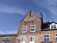
The Big Lock
The Big Lock pub stands alongside, now expanded into the adjacent building that looks suspiciously like old canal stabling. The pub is popular as a food venue and has an attractive Dutch style gable and some fancy terra-cotta work over a doorway.
Once down Big Lock, it is not far before green fields take over and the scenery gets much more attractive. We hadn’t seen much of green fields since we arrived at Wheelock almost a week ago. The journey to Middlewich last Wednesday was largely shrouded in a grey, wet cloak.

Croxton Aqueduct
The canal meanders between open fields and woodland, following the River Dane which it crosses on the aforementioned narrow Croxton Aqueduct. It is a most attractive section. The canal widens every now and then with flashes, caused by former salt workings subsiding, giving a sensation of cruising on The Broads. But woe betide any boater who strays off the beaten track as they are very shallow.
Glimpses of Whatcroft Hall can be seen through the trees, its two handsome lodges sit on both sides of the entrance drive as it crosses over the canal. Judging by the BMW’s in the driveways, they are privately owned nowadays.
After passing under a little used railway line and round a sharp bend, the canal reaches the complexes of wide lakes and separate pools that are known as Billinge Green Flashes. These make an idyllic backdrop to the canal and, essentially, an end to the delightful countryside we have been passing through. It does degenerate now.
The flashes are a popular mooring place although today they were bereft of boats. We have moored there before, most noticeably in 2005 when England won the second test against the Australians by just 3 runs in a nail biting finale. Elaine had to go out and polish the brasses as I was so tensed up, walking up and down inside the boat as I couldn’t keep still!
After the moored boats of Orchard Marina, the canal enters a semi industrialised section. The aroma of freshly bake bread wafts over from Robert’s Bakery who supply supermarkets in this area. After the houses of Broken Cross, the canal steers a course through the middle of the huge Brunner Mond works.
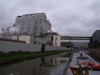
Brunner Mond works, Broken Cross
A network of gantries and pipe bridges criss-cross the canal. Steam belches from open pipes and valves. Unseen machinery hums away. Strange aromas tickle the nostrils. It is cruising, Jim, but not as we know it.
Mind you, as we exited the maze of pipes at the far end we were assaulted by an evil stench that caught and burned the back of your throat. Thankfully we were soon through, and downing our half past 10’s. It does make you wonder if it damages your insides in some way, though. The stench that is, not Elaine’s squash & choccie biccies!
Wincham Wharf with its jumble of boats follows with the canal now entering a most nondescript section. A lot of derelict land, formerly salt workings and chemical works, surrounds the canal. Some redevelopment has taken place, but the outskirts of Northwich, which include the settlements of Broken Cross, Wincham, Lostock Gralam, Marston and Anderton make for a pretty dismal landscape.
A large fertiliser factory adds another not altogether pleasant niff to the air, whilst on the opposite side, an old derelict house and outbuildings, affected long ago by subsidence and settling at all angles, has now finally been demolished.
Further on there are most encouraging signs at the Lion Salt Works that featured some years ago on BBC’s Restoration programme. After a long campaign, Lottery funding has been obtained and a programme of rebuilding and restoration is finally under way. The works were the last open pan salt works in the country and are a remarkable example of what was once a thriving industry hereabouts.
The straight line of the canal immediately after is the result of a 1950’s rebuilding as the original line was constantly being affected by subsidence. More flashes appear on both sides of the canal.
Having spent 5 nights at Middlewich, our loo situation was close to critical, and we regrettably passed by our favoured mooring just at the end of the long straight here. Round the sharp bend, the canal essays a passage through the woods and bluebells of Marbury Country Park – a popular walking area for locals and their dogs.
Anderton Sanitary Station then comes into view. We usually stop here on our way to and from the Bridgewater Canal as facilities on that canal are few and far between and not too salubrious while we’re about it. It is usually thronged with boats and we normally have to mawmble around until a vacancy appears. Today, however, its moorings were empty and we cruised straight in and emptied both loos, got rid of the rubbish and filled up the water tank. Needless to say, soon after we turned on the water tap two other boats appeared wanting to use the facilities and the second one had to do what we usually have to do – mawmble.
Having completed our sanitary duties, we moved on past the entrance to Uplands Marina and tied up on the mooring rings opposite the Alvechurch Marina and hirebase we used when we cruised the 4 Counties Ring on ‘Gannet’ in 2001, our last but one hire boat holiday.
Mooring at Anderton